Tingtibi-Manas Trek
The northernmost tip of the Royal Manas Park
Gelephu (Sarpang district) – Gomphu (Zhemgang)
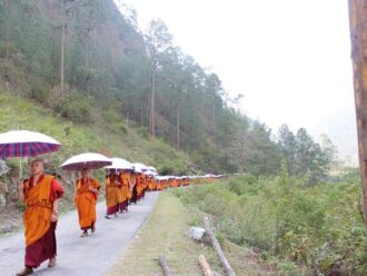
Gelephu under Sarpang district, at one time, was called Hati Zar due to high population of elephants. Gelephu is at 280 m above sea level and is the largest flat land in Bhutan. Take the 150km drive from Gelephu to Gonphu and enjoy the ascent from 280 m-1450m. We pass through Surey village where mandarin and cardamom farming is the main cultivation. From Surey we can also see Jo Dungshing peak on clear days. This peak is the highest in the Black Mountain range. It will be nice to break the journey and camp at Chaplikhola which is under good forest cover. This is the northernmost tip of the Royal Manas Park. The area gets maximum rainfall in the country. This makes the area a thriving subtropical ecosystem. This is the haven for wildlife such as tiger, leopard, clouded leopard, samber, and large number of bird species.
Driving through Chaplikhola we continue through the forest until Tamala pass (2500 m). There are few households here and halting here to look for Royal Bengal tigers would be a nice idea. This is the main tiger habitat.
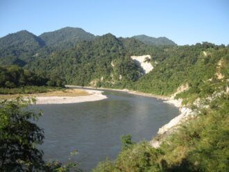
Next we drive further to Tingtibi along the national highway. Tingtibi is located at an altitude of 600 m in a narrow valley by the side of Mangdichu River (the river that runs from the district of Trongsa and joins Manas). Tingtibi is also the junction where the Royal Manas Park boundaries meet the Jigme Singgye Wangchuck National Park.
Tingtibi is the best place to camp for bird watchers. From here we take the farm road to Gongphu. 50 kilometres of bumpy drive on a 4wd. Gongphu is also the crossroad from which one takes the two hours walk to Dunmany hot spring.
Gomphu – Mamung – Pantang
Gear up your bags and start the five hours walk to Pantang village. We will be descending almost 1200 m. On the way stop by at Paibang and Mamung villages. Except for the few remnants of shifting cultivation, the forest cover is seen well-preserved. From Mamung we get to the broad leaved evergreens all the way till Pantang located near the Mangdechhu River. It is quite a place to camp at 280 m above sea level.
Gear up your bags and start the five hours walk to Pantang village. We will be descending almost 1200m. On the way stop by at Paibang and Mamung villages. Except for the few remnants of shifting cultivation, the forest cover is seen well preserved. From Mamung we get to the broad leaved evergreens all the way till Pantang located near the Mangdechhu River. It is quite a place to camp at 280m above sea level.
Pantang – Changna Zam
Take a gradual walk through Phangkhar village located on the other side of the Mangdechhu River. Continue through and cross to Goshing village using the suspension bridge called Phangkhar Zam. The next village is called Shilingtey. The views are terrific but the steep drop from Shilintey to our camp is something to be careful of. It is so steep that a miscalculated step could lead to disaster.
Changnga Zam– Manas
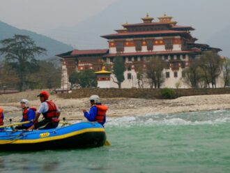
We are heading to Panbang which functions as sub-district headquarter for surrounding Zhemgang villages. It takes three hours through open grasslands following the Mangdechhu River. On the way ask for the first village of Reepatey to avoid losing your trail. Once you reach Panbang the choice is three-fold: you can walk, drive or take a wooden boat ride to reach Manas epicentre. It is a 12 km drive and may take another forty-five minutes. On foot, it might take a few hours, but the boat ride takes only thirty minutes. Many prefer boat rides to enjoy the scenic beauty and watch birds.
To Gelephu from Manas
Manas –Baltegurung
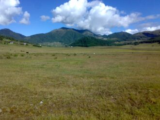
Start early to enjoy wildlife watch. We are heading for Sukunjan and then proceed to Baltegurung camp. Today is the day to watch water buffaloes and wild gaurs and other magnificent ungulates. We are walking through the grasslands which are ideal habitat for Tigers. This stretch starts from Galongkhola and ends within the Kanamakra vicinity. Within a few hours we reach Goburkunda where a stream flows through. Let us stop here for lunch and also take an opportunity to watch wildlife. Many creatures come here to enjoy the benefits from this stream. After a good rest follow the trail to Sukunjan through the grassland. Continue to Baltegurung which is close to two hours from Sukunjan. The riverbeds of Batlegurung have some salt deposits and wild animals love to lick. The saltlick gives us a great opportunity to watch animals.
Baltegurung– Kanamakra
Start the day towards Teendoban which is close to two hours walk through the grassland. This is where you can watch wild elephants and also the rare Kaula trees. The bark of Kaula trees are used in indigenous medicine and are highly sought after. We are very close to the Indian borders so be alert. Sometimes tourists and poachers meet accidentally. This becomes a moment of scaring each other. From Teendoban we walk through the grassland till Kuklung where we lunch on by the riverside.
After lunch walk for another two hours through grassland and some forests of hardwood trees. There are large black soil-lick areas on the riverbeds of Kanamakra. This is the favourite spot for elephants and ungulates.
In summer months Kanamakra is cut off for at least five months and reaching here becomes difficult. During the winter months Kanamakra River becomes a haven for aquatic lives.
Kanamakra – Umling – Gelephu
We head towards Umling via an abandoned sugarcane plantation. The plantation was stopped because this region was inhabited by wild elephants. If you are in hurry, you can drive 29 km to Umling and then another 12 km to Gelephu. Do not do this in summer because Mao Khola River stands powerful.